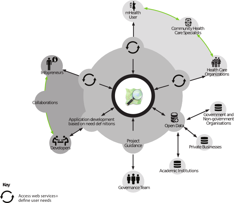
The Global Healthsites Mapping Project is building an open data commons of health facility data with OpenStreetMap. We believe that by leaning on the methods and infrastructure of OpenStreetMap, baseline health facility data can be maintained.
The Global Healthsites mapping project
https://youtu.be/S5Y-A_unnuc
Le projet de cartographie des sites de santé mondiaux
https://youtu.be/gas5D8CSs2U
https://wiki.openstreetmap.org/wiki/Global_Healthsites_Mapping_Project
Key activities of Healthsites include:
- Enabling National health agencies and organisations to share and contribute data to OpenStreetMap
- Enabling collaboration between national health agencies and volunteer communities
- Connecting multiple data streams to build higher quality data
- Explore Human Centered Design to drive the development of the data
Saving health facility data to OpenStreetMap improves interoperability and harnesses the contributions of citizens, academic institutions, businesses and organisations who use the data in their daily operations. In addition to cost savings, improved health facility data supports epidemic preparedness, immunization programs, disaster response, Maternity care and Health capacity planning.
When a natural disaster or disease outbreak occurs there is a rush to establish accurate health care location data that can be used to support people on the ground. This has been demonstrated by events such as the Haiti earthquake and the Ebola epidemic in West Africa. As a result, valuable time is spent establishing accurate and accessible baseline health data. Healthsites establishes this data and the tools necessary to upload, manage and make this data easily and readily accessible. The data is published to the Humanitarian Data Exchange where the #HXL tag is applied. HXL is a simple standard for messy data. Use HXL hashtags to speed up data processing and create interoperability across data sources. Please get in contact if you have idea's for data mashups you'd like to see.
Healthsites convene's an Emergency Health data call where we define priority user stories in support of this baseline health facility data. These priority user stories allow us to identify which services are the most important.
Examples:
As a pregnant mom expecting twins I would like to know where the nearest emergency care facility is so that I know where to go if I experience complications during childbirth
As an epidemiologist I want to know which health facilities have ICU beds so that I can support patients suffering from disease
Identified attributes = Emergency care, ICU beds
Get in touch if you have stories to share and /or would like to join the call.
6 Comments
Mark Herringer
Which of the countries that work with DATIM have open data policies that would support sharing of master facility lists to OSM?
Which countries should we focus on in support of data governance policy?
What are the user stories Healthsites could focus on in support of PEPFAR?
Mark Herringer
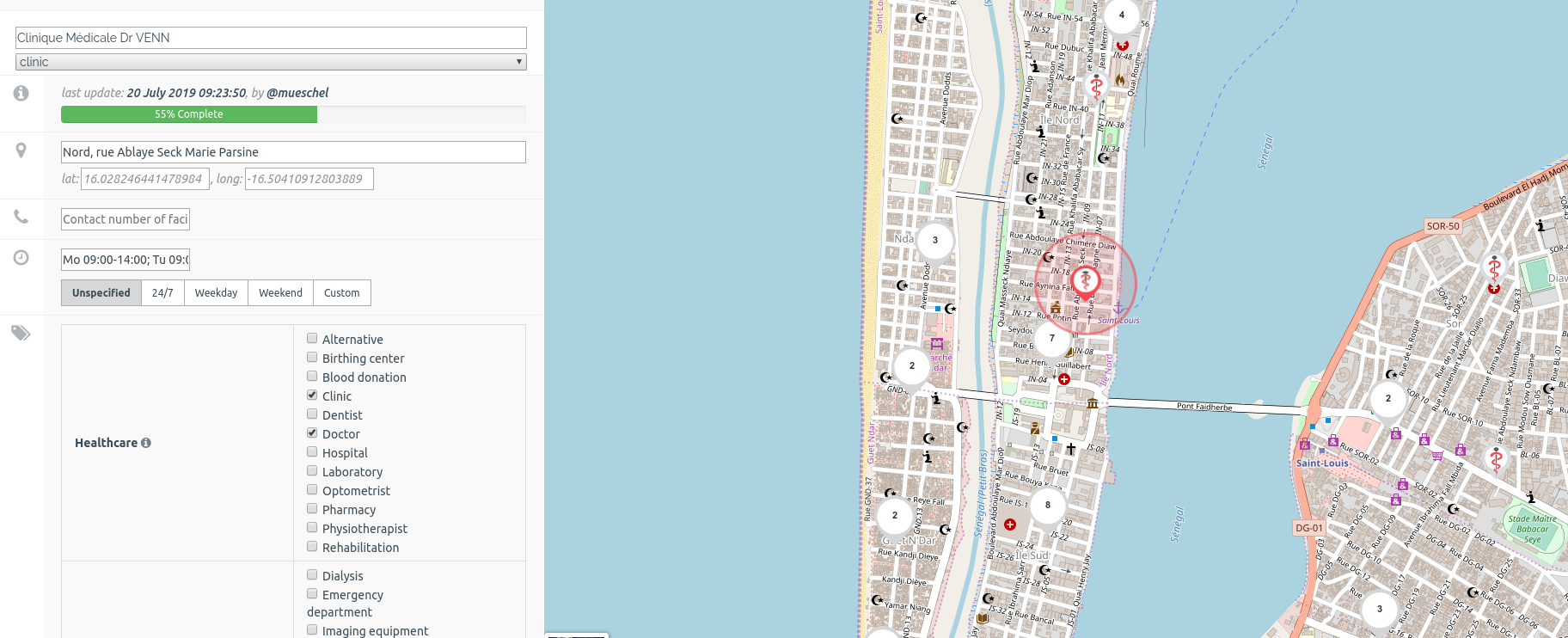
Here is an update on our work in Senegal where we identifed the emergency health user stories from the people who live in the area to drive the data validation process.
This COVIDaction funded campaign work was completed in three months and gave the field team the opportunity to validate 398 health facilities in the medical district of Saint Louis.
The method
Saint Louis, Senegal - Emergency Health Data Validation
centre de sante de dagana - hospital
Please get in contact if you're interested in running a campaign to validate baseline health facility data.
Mark Herringer
This open scientific method has been presented at OSM Science at State of the Map Europe 2023
Developing a data validation method with OpenStreetMap Senegal and the Ministry of Health in support of accurate health facility data
Get in touch if you have ideas on how we could maximize the impact indicators (SDG 3.8.1)
Jennifer E Shivers
There are facility registries being created to help with management. (OHIE community members have software and some countries have developed their own solutions.) However the governance model of the facility data is often a bigger challenge than the technology.
Some countries have decided that some data in their FR (facility registry) is open. Others are not quite there.
Many countries have a first use case to share the facility data with systems like DHIS2 so that there is one coordinated and aligned list in the country.
PEPFAR has been working to align their facility list with countries' lists. This is important as they move toward electronic exchange of data.
Mark Herringer
Do we know which countries have established an open data policy governing health facility data?
Jamie Thomas
Martin Osumba Rita Sembajwe Adam Preston any feedback on this?